


Course locale

choubaka77
User
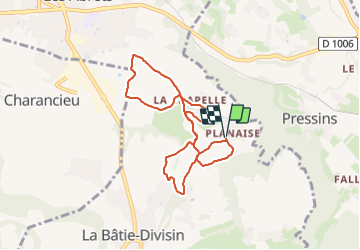

Length
8 km

Max alt
498 m

Uphill gradient
122 m
Km-Effort
9.6 km

Min alt
410 m

Downhill gradient
122 m
Boucle
Yes
Creation date :
2023-06-27 07:40:53.0
Updated on :
2023-06-27 08:35:04.706
53m
Difficulty : Easy

FREE GPS app for hiking
 SityTrail
IGN / Geographical institutes
SityTrail Plus
The world is yours!
About
Trail Running of 8 km to be discovered at Auvergne-Rhône-Alpes, Isère, Les Abrets en Dauphiné. This trail is proposed by choubaka77.
Positioning
Country:
France
Region :
Auvergne-Rhône-Alpes
Department/Province :
Isère
Municipality :
Les Abrets en Dauphiné
Location:
La Bâtie-Divisin
Start:(Dec)
Start:(UTM)
704110 ; 5044265 (31T) N.
Comments